

- Portuguese company uses artificial intelligence to fight wildfires
- US government agencies are increasingly using drones to put out wildfires
- The California Forest Observatory uses satellites and AI to monitor wildfire risk
- Can technology help us solve the growing wildfire problem?
Despite repeated warnings from the scientific community about the gravity of the issue, our greenhouse gas emissions continue to rise year after year, resulting in deadly heatwaves, devastating wildfires, severe droughts, and powerful hurricanes. While these extreme weather events once used to be few and far between, they’ve become more frequent and lethal in recent years, a direct consequence of climate change. According to Munich Re, one of the world’s leading insurance companies, weather and climate events killed more than 4,000 people worldwide and caused around $42 billion in insured losses in 2019.
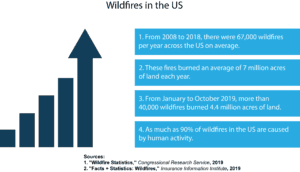
Wildfires in particular have become increasingly destructive in recent years. An average of 67,000 wildfires per year were recorded over the last 10 years in the United States, burning an average of 7 million acres of land, according to the National Interagency Fire Center (NIFC). The same source also revealed that there were more than 40,000 wildfires across the US between January and October 2019, burning 4.4 million acres of land. While this indicates that the number of wildfires has decreased compared to the annual average, they have increased in severity, as evidenced by their growing impact on human communities.
The US Department of Interior estimates that around 90 per cent of wildfires are caused by human activity, ranging from unattended campfires, negligently discarded cigarettes, and the burning of debris to intentional acts of arson. Lightning and lava are the cause of the remaining 10 per cent. Unfortunately, it’s becoming painfully obvious that our current fire management and prevention methods are simply not enough to adequately respond to this growing threat. As a result, researchers around the world are increasingly looking for alternative solutions to this problem, with artificial intelligence and drone technology emerging as a promising option.
A Portuguese company uses artificial intelligence to fight wildfires
Detection remains the biggest challenge in the fight against wildfires, with just three per cent of them detected early. To address this issue, the Lisbon-based company Compta has developed a fire detection system called Bee2FireDetection, which consists of surveillance cameras and can automatically detect wildfires while they’re still in the early stages, immediately notifying firefighters and giving them a chance to respond before the fire spreads. According to the company, the system can cover distances of more than 15 kilometres and is capable of detecting a fire within three minutes after it starts.
“The first 20 minutes after a fire ignites are absolutely crucial between what can be an easily contained fire and a major wildfire situation,” explains Vasco Correia, Compta’s director of international business. “The technologies used today such as satellites are not very effective, they take time, are very expensive, so with artificial intelligence we can use regular low-cost cameras and make them smart. We can detect fires as fast as technology will allow us today.” The system consists of optical and thermal cameras, as well as spectrometric equipment that can determine the chemical composition of substances. This information is then fed into IBM’s Watson supercomputer, which has been taught to differentiate between non-fire situations, such as a dust cloud or a swarm of insects, and a plume of smoke that could quickly turn into a deadly fire.
In addition to being able to detect wildfires before they spiral out of control, the system can also predict how a fire might spread by evaluating factors like the terrain, vegetation, wind speed, and humidity. “We are using IBM technology around the back to help feed our algorithms to assess how the fire is going to spread on the terrain. So our technology can recommend the first firefighting measures. It gives that data to the decision makers on how to tackle the fire the best way,” adds Correia.
US government agencies are increasingly using drones to put out wildfires
It may sound counterintuitive to fight fire with fire, but aerial ignition with helicopters and fixed-wing aircraft has been an important element of firefighting efforts in the United States for quite some time. When done properly, a controlled burn can limit the spread of wildfire by burning off overgrown forests and grasslands. The only problem with this type of mission is that it requires flight at a very low altitude, which can be dangerous even when performed by an experienced pilot. As a result, a number of US government agencies, such as the Department of the Interior and the Forest Service, are increasingly turning to unmanned aerial vehicles in their battle against wildfires.
The Department of Interior, for example, recently introduced the Ignis system. Developed by a company called Drone Amplified, the Ignis system consists of a drone equipped with self-igniting plastic spheres filled with potassium permanganate. Right before the drop, the spheres are injected with glycol, which reacts with the potassium permanganate inside and sets the spheres on fire within 30 seconds, giving them plenty of time to reach the ground. A single drone can carry nearly 6 kilograms of spheres. The Department of Interior has purchased eight Ignis systems so far, which have already been put to use in Arizona, California, Nebraska, and Oregon. If everything goes according to plan, the agency will purchase another twenty in the near future.
“We’ll see a drastic increase over the next couple years as the product is adopted more widely – it’ll take off and we’ll be buying quite a few of them over the next few years,” says Brad Koeckeritz, the unmanned aircraft system division chief for the Department of Interior’s Office of Aviation Services. In addition to eliminating risks to human pilots, the Ignis system is also capable of flying in dark and smoky conditions, and it gives the operator more control over the prescribed burn by allowing them to drop the spheres in a precise pattern over the landscape. Furthermore, should they lose radio signal or GPS during the mission, the drones are programmed to automatically return to their original launch point.
The California Forest Observatory uses satellites and AI to monitor wildfire risk
California is a region especially susceptible to wildfires, with more than half of its forest area estimated to be at high risk of a megafire. To make this problem even worse, the current wildfire risk maps used by the California Department of Forestry and Fire Protection (CalFire) are outdated and fail to incorporate crucial weather data. To address this issue, the conservation tech company Salo recently joined forces with Vibrant Planet and Planet Labs to develop the California Forest Observatory (CFO), an open-access platform that provides a statewide map of the forest structure and fuel loads down to the tree level. The platform features a sophisticated AI engine that combines high-resolution satellite imagery with weather, climate, population, and infrastructure data, as well as contemporary wildfire models, to provide a real-time, dynamic map of wildfire risk for the state of California.
“With a majority of California’s forests at high risk, the Observatory comes at a crucial time,” says Helge Eng, CalFire’s deputy director of resource management. “The data and technologies available today can help us better see, understand, and mitigate risk, as well as coordinate action to save lives and property.” In addition to being used as a forest planning and monitoring tool, which will be its primary purpose, the Observatory could also have potential applications in many other areas, including emergency services, risk management, insurance, agriculture, and scientific research. The satellite imagery will be updated daily, while frequent consultations with experts in land management, emergency services, forest ecology, wildfire, meteorology, hydrology, wildlife biology, user experience, and cartography will ensure that the design and build of the platform remain optimal. “The velocity of action is always limited by the velocity of information,” says Andrew Zolli, the vice president of Global Impact Initiatives at Planet Labs. “By providing a much more dynamic, near-real-time view of California forests, we hope to enable many actors to move faster and more effectively.”
Can technology help us solve the growing wildfire problem?
Extreme weather events like heatwaves, wildfires, droughts, and hurricanes have always been a natural part of human existence on Earth. However, their frequency and severity has grown significantly in recent years, primarily as a result of climate change. Wildfires in particular have become increasingly destructive, making our current fire management and prevention methods painfully inadequate for the task. To address this problem, researchers around the world are increasingly turning to technologies like artificial intelligence, satellites, and drones.
From AI systems that automatically detect wildfires while they’re still in their early stages and satellites that monitor wildfire risk in real time to drones that fight fire with fire, technology has taken on an increasingly prominent role in global fire prevention and suppression efforts. Thanks to these innovative solutions, we now have the ability to monitor wildlife risk in real time, detect wildfires before they spiral out of control, predict how they might spread, and put them out using unmanned aerial vehicles, saving both people’s lives and protecting their homes from going up in flames.